Trou D'eau Douce
The village where all begin!
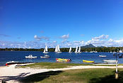
Trou d'Eau Douce is a village on the east coast of Mauritius, in the district of Flacq.
The village takes its name from the fact that a place on the shore, Belle Isle, source of drinking water and comes in contact with salt water. The first inhabitants of Mauritius were the Dutch, but they do not remain. Batavian ships landed on the island for supplies of water and food
( turtles and dodos ), when traveling to and from their colonies in the Dutch East Indies.
Trou d'Eau Douce was one of the first places in their supplies of water, hence the name.
The first houses date from the period 1653 - 1 658, under the government of Reiner Por.
On a map of Pieter van der Aa, dating from 1721, Trou d'Eau Douce appears under the name Oostersgat, literally " the hole is. " In 1655, the village was with Flacq Grand Port Bay, the only homes Batavian island. The period of French colonization was more prosperous.
The names of several neighborhoods show Rise Bastille, La Peyrousse, Le Maho, Landing, Seven Crusades, and Camp Nadal, among others. But there are also sounding names Dutch as Despéroux or British like Victoria.
The village had a plant sugar cane in Victoria and a lime kiln Le Maho. The lime was an essential component in the production of sugar in the former. With the abolition of slavery in 1839, many freedmen stopped working in the fields and settled along the coast, especially to Landing and Le Maho, and lived fishing. Hence the origin of the tradition of fishing in
Trou D'eau Douce.